
The National Oceanic and Atmospheric Administration just released its 2018 hurricane forecasts. Here’s what you need to know. Just the FAQs
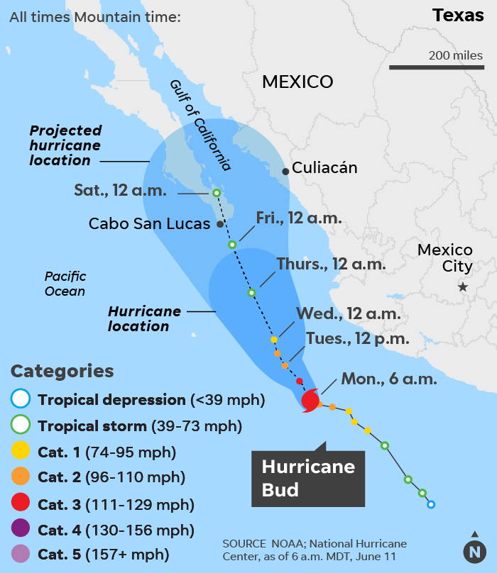
Hurricane Bud, now swirling off the west coast of Mexico as a Category 3 storm, is forecast to bring heavy rain to Mexico and possibly the Southwest U.S. over the next few days.
While rainfall from Bud or its remnants would be beneficial to the drought-stricken Southwest, it could also cause flash floods if too much falls too quickly, according to AccuWeather.
The worst drought in the U.S. is in the Southwest, with the most severe conditions in Arizona, New Mexico, Utah and Colorado.
As of 2 p.m. ET, Bud had winds of 120 mph and was moving to the northwest at 7 mph. It was located about 450 miles south-southeast of the southern tip of the Baja peninsula in Mexico, the National Hurricane Center said. A tropical storm watch remained in effect for portions of Mexico’s west coast from Manzanillo to Cabo Corrientes.
Swells from Bud “are likely to cause life-threatening surf and rip current conditions” along the west coast of Mexico, according to the hurricane center. In addition, rain from Bud “could cause life-threatening flash floods and mudslides in higher terrain.”
Rainfall amounts of 4-8 inches are expected with local amounts up to 12 inches through Wednesday, AccuWeather said. Small rivers and streams may quickly rise out of their banks and turn into deadly torrents.
Bud is the second hurricane of the eastern Pacific hurricane season, following Aletta, which is rapidly weakening far out in the open ocean. This is unusually early for two hurricanes to have formed, as the average date for the second hurricane to form in the eastern Pacific is July 14, Colorado State University meteorologist Phil Klotzbach said.
The eastern Pacific hurricane season is forecast to be quite active, thanks in part to a developing El Niño. NOAA predicts that seven to 12 hurricanes will form.
El Niño could also put a damper on the Atlantic hurricane season.
In the Atlantic basin, the hurricane center said there’s a 20% chance that a tropical depression or storm will spin up witin the next five days in the Caribbean or the Gulf of Mexico.
However, even if it doesn’t become a named system, the risk of heavy rainfall, rough surf and gusty thunderstorms will increase later this week from the northeastern coast of Mexico to coastal Texas and southwestern Louisiana, AccuWeather warned.
The next storm that forms in the Atlantic, the Gulf of Mexico, or the Caribbean Sea will be given the name Beryl.
Read or Share this story: https://usat.ly/2JDl4YW
more recommended stories
 Fentanyl Seizures at Border Continue to Spike, Making San Diego a National Epicenter for Fentanyl Trafficking
Fentanyl Seizures at Border Continue to.
 Utah Man Sentenced for Hate Crime Attack of Three Men
Tuesday, August 8, 2023 A.
 Green Energy Company Biden Hosted At White House Files For Bankruptcy
Aug 7 (Reuters) – Electric-vehicle parts.
 Former ABC News Reporter Who “Debunked” Pizzagate Pleads Guilty of Possessing Child pδrn
Friday, July 21, 2023 A former.
 Six Harvard Medical School and an Arkansas mortuary Charged With Trafficking In Stolen Human Remains
SCRANTON – The United States.
 Over 300 People Facing Federal Charges For Crimes Committed During Nationwide Demonstrations
The Department of Justice announced that.
